
Three Sisters Canmore: How to find the viewpoint
Some links in this post are affiliate links. This means if you purchase something through my links I may make a small commission at no extra charge to you. See my disclaimer.
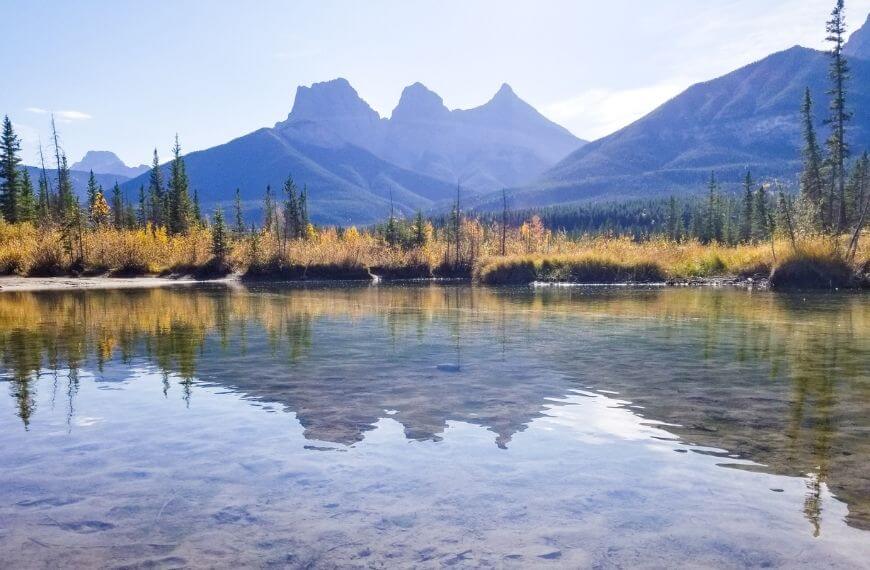
The Three Sisters in Canmore are one of the best-known clusters of mountains in the region. They’re the most recognisable mountains in all of Canmore.
What’s interesting is that each of them has a name and a brief story.
Back in the 1800s, Canmore was a quiet mining town with a population of between 200 and 300 people. After a particularly powerful snow blizzard in 1883, the mountains were each covered with snow only on their north faces.
This created the illusion of nun’s veils and inspired Albert Rogers to name the mountain peaks “the three nuns”.
Just three years later, in 1886, George Dawson renamed the mountains the Three Sisters, and they quickly became a popular feature in Canmore. Individually named Big sister (Faith), Middle Sister (Charity) and little sister (Hope). As you can see, they each have two names.
Check out our Hub pages for your Canada Trip:
Canada Working Holiday Hub
Working Holiday Visa Hub
Gap Year Planning
| Country: | Canada |
| Currency: | Canadian Dollar / CAD / $CAD |
| Do you need a visa to visit as a tourist? | Check here |
Don’t forget to get travel insurance to cover you if something bad happens. One company I have personal experience with is Safety Wing. Not everyone needs the same coverage, so make sure you get a personalised quote that suits you and your trip plans.
Mountain Stats
Big Sister
2,936 m tall
First climbed in 1887
Middle Sister
2,769 m tall
First climbed in 1920
Little Sister
2,694 m tall
First climbed in 1925
Getting to the viewpoint
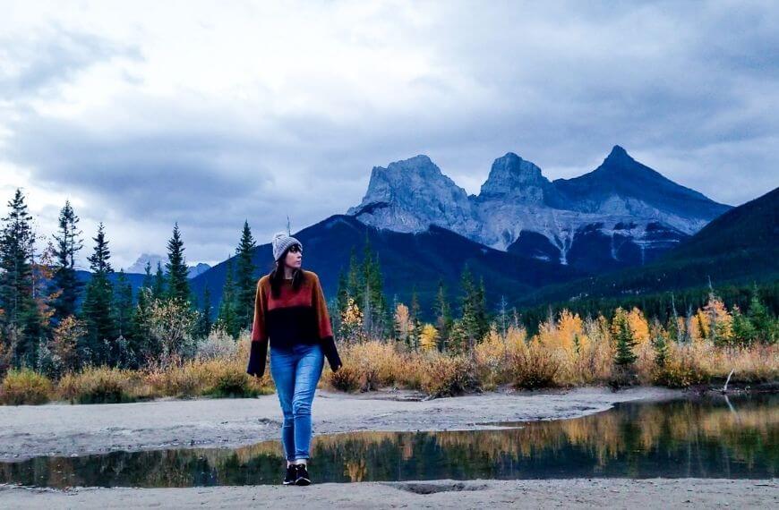
So you can actually see the three sisters from multiple places in town, but this viewpoint near the creek is probably my favourite of them all.
What I found is that when you search “Three Sisters viewpoint”, one comes up on Google Maps, but I honestly didn’t like it too much. It is just an opening at the side of the road.
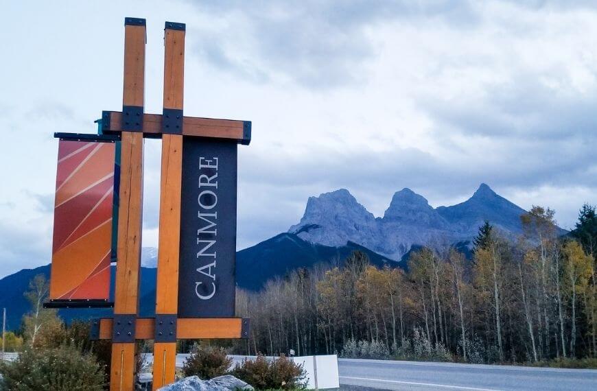
If you are staying locally in downtown Canmore, you’re only a short walk away. Instead of following Google Maps to the one listed, you want to follow the “Bow Valley Trail” road. This is one of the main roads in and out of Canmore off the Trans-Canada Highway and is a route often taken to and from Calgary.
With the Canmore downtown shops behind you, and the Three Sisters in the distance slightly to your right, make your way down the Bow Valley Trail.
Safety tip: Walk on the left side of the road (same side as Solara Resort and the Helicopter Alpine Co) since the other side does not have pavement for you to walk on.
The best way to stay connected and make the most of navigation apps so you can successfully travel around Canmore is to get a local SIM. Instead of waiting for a physical card to be delivered, you can get an eSIM through Airalo, which is downloaded straight to your phone.

To the Trailhead
Walk as far as the “Off-Leash Dog Park” and then SAFELY cross the road into an unmarked car park (it’s basically just a gravel clearing). I like to consider this the trailhead.
From the gravel clearing, you will see a concrete bridge and the railway track. You will need to walk underneath the bridge, so please make sure you use caution. Keep following the gravel road until it curves slightly to the left. You will eventually find a small forest trail that has been clearly walked on.
Follow this through until you reach a small body of water, which is part of the Policeman’s Creek. This normally takes a few minutes along the trail, and you can’t go wrong!
The Policeman’s Creek stream is the same creek that you walk alongside during the Boardwalk trail in the town centre.
Eventually, you will reach a small clearing, which is your final destination.
Well done, you have reached the (better) Three Sisters viewpoint, one of the highlights of Canmore! During the different months, the amount of water seen here will vary. In winter, it is mostly frozen over with lots of snow. In summer, there is less water due to it being hotter and drier.
Want to make the most of your time in the local area? Book this walking tour to look for local wildlife and scenery.
When you need to transfer money or check exchange rates during your overseas trip, consider using Wise. They have competitive rates and make exchanging foreign funds easy. I’ve been using them since 2015.
Spending a few days in Canmore? Why not check these other posts:
- 10 Stunning hikes in Canmore you can walk to
- Grassi Lakes Hike in Canmore: The popular trail
- Quarry Lake walking trail in the Canmore Rockies
- Spring Creek Canmore: A Beautiful boardwalk trail
- How to walk the Bow River Loop trail in Canmore
Want a more difficult trail to tackle in Canmore? Check out the EEOR Hike in Alberta – The East End of Rundle
When to visit The Three Sisters Hike in Canmore
As this is an accessible location no matter the weather, it can be visited at any time of year. In winter, you will see ice and snow, and in summer, it will be very green. Many photographers use this viewpoint to capture sunrise and sunset shots of the mountains.
On a cloudy day, you get a much better sunrise photograph due to the clouds creating more colours and the position of the sun. I would highly recommend making the short walk for sunrise on at least one of your days in Canmore.
Tip: Because the Rocky Mountains are so picture-perfect, you can get great photos almost anywhere at sunrise. My favourite sunrise spot was on the EEOR trail if you’re up for a more challenging walk.
Other Three Sisters Hikes in Canmore
To get to Canmore, find cheap flight tickets, you can check out www.Booking.com or www.Expedia.com. I used both interchangeably when comparing prices.
This post is about finding the Three Sisters viewpoint so you can get the best pictures of the mountain trio. Since this is Canmore and part of the Rocky Mountains, there are multiple other hikes involving the Three Sisters that you can also check out while visiting the area.
Check them out below:
- Three Sisters Creek – This route is easily accessible for all skill levels and is mostly flat terrain. It features wildflowers and surrounding forests and is used by mountain bikers as well as hikers. This is a 3.4km hike.
- Three Sisters Pass – A trail that follows the length of a river and features a waterfall is popular in the area. This 5km trail is all uphill and features some great mountain views from the top of the viewpoint.
- Powerline Track to Three Sisters trail Starting on the other side of Canmore near Rundle Forebay, this trail takes you all the way to the powerline track. If you continue along the full trail you will eventually reach Quarry Lake and Loki’s low-line trail. This takes roughly 3-4 hours to walk.
It is not possible to hike all three mountain trails within one day due to the difficulty of the hike on Charity Mountain. This isn’t even attempted by experts with appropriate rock climbing gear.
Be aware: There is also an extremely dangerous traverse in between the mountains, which means you cannot get from one to the other.
Accommodation
If you’re planning to stay in Canmore (rather than travelling in for a day trip from Banff), you probably need somewhere to stay. Depending on your travel style, you have a few different accommodations to choose from.
- Canmore Downtown Hostel – Fun, sociable and budget-friendly hostel with a large common room. It is so easy to meet other travellers here, and there are always events advertised. This is located in the courtyard of the central Canmore shops, 15 minutes from the viewpoint.
- Solara Resort – A more luxurious accommodation on the Bow Valley Trail for visitors who want more of their own space. Private rooms in a quiet resort with mountain views. Only a 10-minute walk from the viewpoint.
So there you have it. If you want to find the (better) viewpoint than what is listed online, follow these steps and let me know what you think!
Resources to Help You Plan Your Trip
Check out how to plan a trip abroad & see my travel resources for more.
Skyscanner – A comprehensive comparison website showing where to purchase flights.
HostelWorld – The biggest selection of hostels & sociable accommodations.
Booking.com – The largest collection of accommodations AND flights worldwide.
Safety Wing – A travel insurance brand for long-term travellers and nomads.
Airalo – An eSIM card company that lets you stay connected during your trip.
Wise – Perfect for transferring foreign currencies.
iVisa – For applying for tourist and visitor visas.
Viator – Great for finding tours and activities worldwide.
Get Your Guide – Another company for finding activities.
Klook – Has some of the best activity deals in Asia.


Great info, thanks!
What a neat story of how the Three Sisters got their name and I love that you included the directions to find their best viewpoint. Thanks for including some accommodations too!
This looks like a stunning place to go hiking! I sometimes get lost so I appreciate this guide on how to find the viewpoint.