Bongnaesan Mountain: A short hike with great views
Some links in this post are affiliate links. This means if you purchase something through my links I may make a small commission at no extra charge to you. See my disclaimer.
The Bongnaesan Mountain hike is another easy walking route that gives you great views for minimal effort in Korea’s second-largest city. It’s the most southern mount in the Busan metropolitan area and is located on Yeongdo Island near Busan Port.
Considering many of the shorter hikes get ignored or overlooked in the city due to the sheer number available, it’s always a bonus to find a short trail with panoramic sights.
And, well, this one gives you exactly that! That’s why it’s one of the best hikes in Busan!
This is the perfect trail to spend a little time admiring the coastal landscape around the city without breaking much of a sweat.
Check out the Bongnaesan mountain walking route with me.
| Country: | South Korea (Republic of Korea) |
| Currency: | South Korean Won / KRW / ₩ |
| Do you need a visa to visit as a tourist? | Check here |
Want to visit Korea for longer than a tourist? Consider the working holiday H1 visa to stay for 1 year. Plus, see how you can get set up as an expat after arrival.
When you need to transfer money or check exchange rates during your overseas trip, consider using Wise. They have competitive rates and make exchanging foreign funds easy. I’ve been using them since 2015.

Bongnaesan Mountain trail stats
Length of trail:
2.70 km / 1.60 miles
Elevation gain:
186 m
Time to complete:
1 hour and 5 minutes
The Bongnaesan Mountain hike is an out-and-back walking trail on Yeongdo Island in Busan. It’s a straightforward hike compared to many others in the area. What’s great about this paved walking trail is how it takes minimal effort for the great reward of the views of South Busan.
This trail is suitable for most fitness levels as the majority of the route is a gradual incline along a well-looked-after wooden boardwalk. There are a few places to take shortcuts if you do enjoy more of a challenge, which we will get into later.
Want to visit some more hikes in Busan?
- Jangsan Mountain, Busan’s popular city hike
- Geumjeongsan Mountain, Hiking the highest peak in Busan
- Exploring viewpoints on the Hwangnyeongsan Mountain hike
- Enjoying the Igidae Coastal Walk in Busan
- Seunghaksan Mountain: Completing the Loop Trail
If travelling by public transport, don’t forget to top up your T Money card!
This is an extremely easy-to-follow trail, so it’s almost impossible to get lost. Although you might not need to use AllTrails (my favourite hiking app) for directions, if you like to keep track of all your hikes, this app allows you to do so. If staying connected is a concern during your trip, Airalo offers eSIMS you can download directly to your mobile phone.
If your phone isn’t able to connect using eSIMs, you can get a physical SIM here instead.
How to get to Bongnaesan Mountain
Location of trailhead: Busan Yeongdo-gu Sinseon-dong 3(sam)-ga 산4-28
The Bongnaesan Mountain hike is located on Yeongdo Island in the south of Busan.
The closest subway station to the Bongnaesan hiking trail is Nampo, found on Line 1 (the orange line). From the station, you can take exit 2 and take the number 9 bus, which will take an average of 40 minutes to arrive.
That bus only runs every 20 minutes, so if you don’t time it right, you will need to take a different bus. The other options from Nampo station are as follows:
- Bus 30 or 113, but this route will require you to walk 15 minutes to the trailhead.
- Bus 71 from outside Jagalchi Traditional Market, with just a 6-minute walk to the trailhead.
Alternatively, foreigners can easily rent cars to drive themselves to the trailhead; just be aware that it can be hard to find parking.
You can rent a car using the following companies:
Don’t forget to get travel insurance to cover you if something bad happens. One company I have personal experience with is Safety Wing. Not everyone needs the same coverage, so make sure you get a personalised quote that suits you and your trip plans.
What to expect on Bongnaesan Mountain

The start of the trail
You will initially be dropped off in a hilly residential area and will need to walk up towards the “Sweet Potato Historical Park” to access the trail. The Historical Park is a small children’s playground dedicated to sweet potatoes, and you can’t miss it. From the park, you will continue to walk up the hill along the paved road.
The trail is well-maintained and is a clear path with a slow and gradual incline. There are lampposts along one side, so if you decide to complete the trail in the evening, you will easily find your way.
You will only be walking about 10 minutes up the trail before you get a small glimpse of the view on your right-hand side. You’ll also notice a tall yellow platform towering over you on your left side. This is the first platform viewpoint, and you have two ways to reach it.
- Continue along the paved path slightly until you reach the official entryway to the platform
- Take a sharp left along a shortcut before the purple heart photo opportunity
Realistically, this “shortcut” is only about 5 minutes quicker, so if you would prefer to do things properly, you can, and your time won’t be affected much.
Whichever way you choose to take, you’ll eventually reach a staircase that takes you to the top of the platform. From here, you’ll be able to see Busan port and the ferries that travel to Japan.
Here are the views from this platform:


Walking to the peak
After admiring the views at the first viewpoint, you can get back on track. Heading towards the back of the platform, you can walk through a large hedge. If you take the staircase on your left, you will reach a large radio station. Follow the hill, keeping the station on your right, until you reach a crossroad in the path.
From this crossroad, you can either take the boardwalk on your left or head up the steep stone stairs. It is a little bit quicker to take the stone steps, but it will be more challenging due to the incline.
The stone stairs take you directly to the peak platform, and you will need to scramble along some of the rocks along the way. This route is well-walked, but it is not for all physical abilities as it involves a little bit of climbing.
Please use caution when going up this way, as it can be very slippery after rainfall.

If you are happy to take a more gentle stroll, then you can take the boardwalk route. It won’t take you too long, but it will take you around the mountain to not be too steep at any point.
As you take the boardwalk, you will reach another 2 viewpoints before reaching the top. The trail takes you around the east side of Mount Bongnaesan so you can enjoy the view the entire way. The first platform along this side is only small.
The second is much larger and gives you views of the opposite side of the mountain with a clear glass railing to keep you protected. This railing is safe and secure and is a good way for (supervised) children to also see the view without being lifted up above the railings.
Each of the viewpoints gives you a slightly different perspective of the landscape. On the one hand, you can see the 3 tall towers of Haeundae Beach, and on the other, you can see the small islands and Amnam-Dong.


The peak & final viewpoint of Bongnaesan Mountain
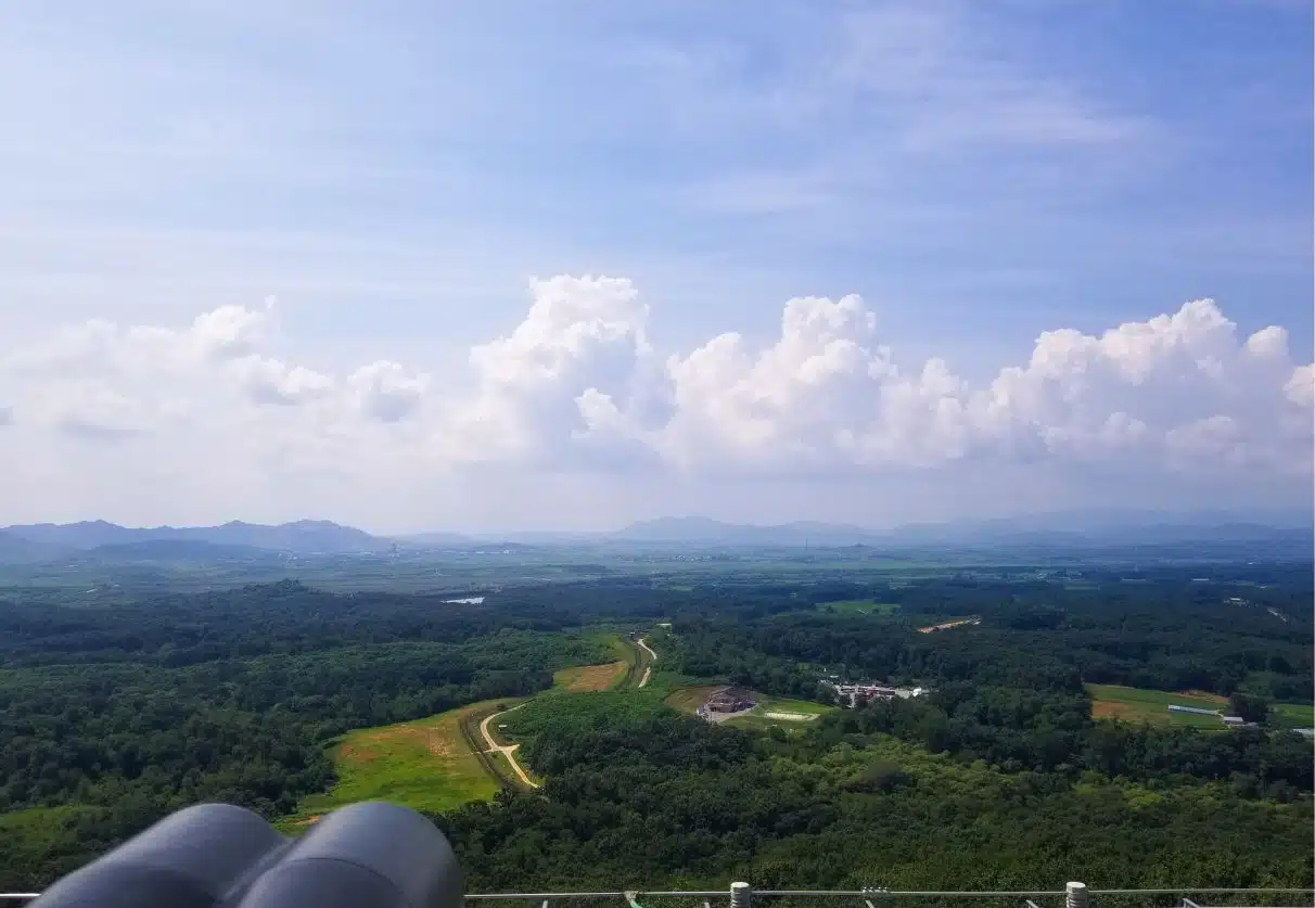
You’ll know you’ve reached the top of the mountain when you reach a very large viewing platform, much bigger than the ones you have passed already. The view is less obstructed than it was on the lower levels, and you will be able to see much further from here.
There are benches located on the platform so you’ll be able to take a rest if need be.
On the platform with the boardwalk path behind you, you’ll see a large pile of rocks that shape the mountain landscape. These are located just next to the peak rock that has the mountain’s name carved into it.
Some people will use these rocks to pose for photos of the view behind them, but the best views are actually located a few feet away, facing in the direction of Amnam-Dong.
There are some parts of the rocks which are flat and easy to walk along or stand on, which makes for a great photo opportunity. Please be careful, though, as the rocks here are not protected with any fences or railings, so you should use caution if heading out to this part of the walking trail.
There are also some steep drops if you get too close to the edge, so take this as a warning.

Best time to visit Bongnaesan Mountain
Because of the direction that the main viewpoints face, this is a great mountain for both sunrise and sunset! Plus, because the walk to the top is so quick and easy, it’s definitely one of the most accessible at both of these times of the day.
If you are arriving before sunrise, you will need to walk along the route in the dark, and you will arrive at the peak before it gets light. To see the sunrise, you’ll have to go to the highest platform and face between the direction of Haeundae Beach (look for the tall towers) and Busan Port to find true east.
Pro tip: The three tall towers in Haeundae have lights on the top and are the highest in the area, so you should easily spot them in the dark.
If you would rather watch the sunset from up here, you will not see much from the platform at the peak, but instead, you’ll need the platform in the middle as it faces westwards. This will give you a stunning multicoloured sky as the sun goes down and the city lights start to turn on beneath you.
Need help preparing for a day hike? You can download my packing list below and customise it depending on the weather and local conditions.
I’d recommend learning some basic Korean before venturing on too many hikes in the country, as many Koreans don’t speak English. This will make things easier for you while navigating around the country.
Since basic Korean phrases will only take you so far, it’s worth considering lessons with a tutor to help you with pronunciation and understanding responses. That’s why I recommend Preply. where you can work one-on-one with a private tutor online. With my link, you can get 30% off your first trial lesson with a tutor.
Final thoughts on the Bongnaesan walking trail
Having walked along many trails in the Busan region, this has got to be one of the easiest trails overall. Fantastic views, ease of access, safe and secure viewing platforms and a clear view for sunrise.
It’s a trail that’s accessible by most people, close to the city, and takes under an hour to complete, which makes this an extremely underrated path that more people should take. Try out the Bongnaesan walking trail next time you have an afternoon free.
Want to hike some more challenging trails? Check out the biggest in Korea:
- Gwaneumsa Trail: Hiking the Steepest Trail of Mt.Hallasan
- Taking the Seongpanak trail to the Hallasan peak
- Jirisan Mountain – Biggest on the mainland
Resources to Help You Plan Your Trip
Check out how to plan a trip abroad & see my travel resources for more.
Skyscanner – A comprehensive comparison website showing where to purchase flights.
HostelWorld – The biggest selection of hostels & sociable accommodations.
Booking.com – The largest collection of accommodations AND flights worldwide.
Safety Wing – A travel insurance brand for long-term travellers and nomads.
Airalo – An eSIM card company that lets you stay connected during your trip.
Wise – Perfect for transferring foreign currencies.
iVisa – For applying for tourist and visitor visas.
Viator – Great for finding tours and activities worldwide.
Get Your Guide – Another company for finding activities.
Klook – Has some of the best activity deals in Asia.